This article is 6 years old. It was published on March 26, 2018.
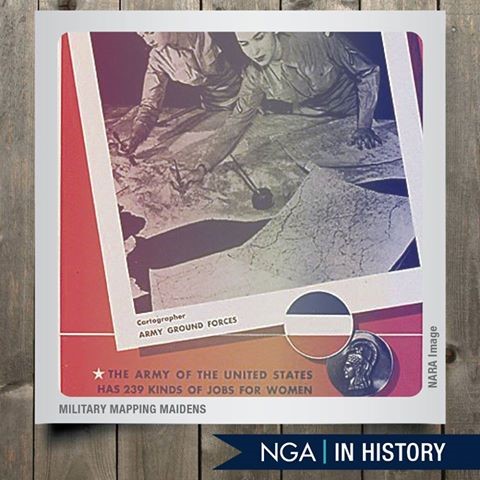
Just as the demand for mapping products was escalating early in World War II, the Army Map Service, an NGA predecessor organization, was losing much of its workforce to the armed forces.
A solution to the urgent need for replacements emerged when the University of Chicago’s Geography Department developed a course in military map making and began offering it to women’s colleges in the East and Midwest.
In its inaugural year, 200 women completed the course. As the program expanded to more colleges, the Army Map Service provided a four-week course that gave recruits further training.
The “Military Mapping Maidens” – or “3Ms” – charted strategic locations, churches, schools, land contours, bodies of water and roads. They used foreign maps, aerial photos and other information to create the maps. Some were printed on silk and carried by troops as survival tools.
-
Contact Information:
Juwanna Brown
Project Manager - Project Connect
Office Phone: (314) 657-3774 -
Department:
St. Louis Development Corporation
-
Topic:
History and Heritage
Most Read News
- Applications for St. Louis Senior Property Tax Freeze Credit Now Live Senior residents can now apply to freeze their property taxes through a new credit enacted by BB 141 (Schweitzer), providing financial relief to those who are burdened by the rising costs of property taxes.
- St. Louis City Municipal Division Moving to Case.net Municipal Court will use Case.net for new cases filed on or after January 2, 2024.
- St. Louis City Awarded Solar For All Federal Grant The City of St. Louis is part of two different coalition groups among 60 selectees that will receive a total of $7 billion in awards through the Solar for All grant competition.