Ward 22 2011 Map
Ward 22 2011 Map
Publication Date: 07/01/2010
Document Type: Maps and GIS
Sponsor:
Planning & Urban Design Agency
Summary
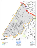
Standard letter size map.
Boundaries: Beginning at the point of intersection of Page Blvd and Belt Ave, and proceeding westerly along Page Blvd to Blackstone Ave, and proceeding southerly along Blackstone Ave to Etzel Ave, and proceeding westerly along Etzel Ave to the St. Louis City county line, and proceeding northerly along the St. Louis City county line to I- 70, and proceeding easterly along I- 70 to Geraldine Ave, and proceeding westerly along Geraldine Ave to Natural Bridge Ave, and proceeding westerly along Natural Bridge Ave to Union Blvd, and proceeding southerly along Union Blvd to Lexington Ave, and proceeding westerly along Lexington Ave to Arlington Ave, and proceeding southerly along Arlington Ave to St Louis Ave, and proceeding easterly along St Louis Ave to Union Blvd, and proceeding southerly along Union Blvd to Dr Martin Luther King Dr, and proceeding westerly along Dr Martin Luther King Dr to Stewart Pl, and proceeding southerly along Stewart Pl to Semple Ave, and proceeding southerly along Semple Ave to Ridge Ave, and proceeding westerly along Ridge Ave to Belt Ave, and proceeding southerly along Belt Ave to the point of beginning.
Population: 10,862 (SF1 2010 Census)
Download
-
 Ward 22 2011 Map
-
Ward 22 Tabloid Size
(344.32 KB)
-
Ward 22 2011 Map with 2021 Ward Overlay
(2.60 MB)
Need Help Viewing?
You need a program that can open Adobe PDF files. A free option:
- Adobe Reader (can read PDF files)