Ward 21 2011 Map
Ward 21 2011 Map
Publication Date: 07/01/2010
Document Type: Maps and GIS
Sponsor:
Planning & Urban Design Agency
Summary
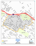
Standard letter size map.
Boundaries: Beginning at the point of intersection of Natural Bridge Ave and Fair Ave, and proceeding westerly along Natural Bridge Ave to Harris Ave, and proceeding southerly along Harris Ave to east/west alleyway between Natural Bridge Ave and Lexington Ave, and proceeding westerly along such alleyways to N Newstead Ave, and proceeding southerly along N Newstead Ave to Lexington Ave, and proceeding westerly along Lexington Ave to north/south alleyway between Natural Bridge Ave and Lexington Ave, and proceeding northerly along such alleyway to east/west alleyway, and proceeding westerly along such alleyway to Cora Ave, and proceeding southerly along Cora Ave to Palm St, and proceeding westerly along Palm St to Marcus Ave, and proceeding southerly along Marcus Ave to Palm St, and proceeding westerly along Palm St to Shreve Ave, and proceeding northerly along Shreve Ave to Sacramento Ave, and proceeding westerly along Sacramento Ave to north/south alleyway, and proceeding northerly along such alleyways to Bessie Ave, and proceeding easterly along Bessie Ave to Shreve Ave, and proceeding northerly along Shreve Ave to Anderson Ave, and proceeding westerly along Anderson Ave to north/south alleyway, and proceeding northerly along such alleyways to Carter Ave, and proceeding easterly along Carter Ave to Shreve Ave, and proceeding northerly along Shreve Ave to I- 70, and proceeding easterly along I- 70 to Adelaide Ave, and proceeding westerly along Adelaide Ave to Von Phul St, and proceeding easterly along Von Phul St to E College Ave, and proceeding westerly along E College Ave to Conde St, and proceeding southerly along Conde St to Linton Ave, and proceeding easterly along Linton Ave to Blair St, and proceeding southerly along Blair St to De Soto Ave, and proceeding westerly along De Soto Ave to W Florissant, and proceeding westerly along W Florissant to Warne Ave, and proceeding westerly along Warne Ave to W Florissant, and proceeding westerly along W Florissant to Mary Ave, and proceeding westerly along Mary Ave to Carter Ave, and proceeding easterly along Carter Ave to Warne Ave, and proceeding westerly along Warne Ave to Kossuth Ave, and proceeding westerly along Kossuth Ave to Fair Ave, and proceeding southerly along Fair Ave to the point of beginning.
Population: 10,869 (SF1 2010 Census)
Download
-
 Ward 21 2011 Map
-
Ward 21 Tabloid Size
(364.95 KB)
-
Ward 21 2011 Map with 2021 Ward Overlay
(1.86 MB)
Need Help Viewing?
You need a program that can open Adobe PDF files. A free option:
- Adobe Reader (can read PDF files)
Help Us Improve This Page
Did you notice an error? Is there information that you expected to find on this page, but didn't? Let us know below, and we'll work on it.
Feedback is anonymous.