Address & Property Search
Your search for 2915 MINNESOTA AV
Basic Info
| Primary address | 2915 MINNESOTA AV ST LOUIS MO 63118 |
|---|---|
| Owner name | L R A |
| Parcel ID | 1454-9-260.000 |
| Collector of Revenue account | 1454-00-02600 |
| Neighborhood | 25 - Tower Grove East |
| Ward/Precinct | Ward 07, Precinct 7 |
| Property Class | EXEMPT |
| Tax Abatement | This property is not abated |
| Property description
Not meant for use in recorded legal documents |
C. B. 1454 MINNESOTA AV, 25 FT X 125 FT, 3RD CITY ADDN, BLOCK 1, LOT 15 |
Maps
Parcel Map
Parcel information, streets, and strategic land use planning (SLUP) information.
Zoning Map
Zoning for this parcel: B. Two Family Residential
Legend
-
 A. Single Family Residential
-
 B. Two Family Residential
-
 C. Multi Family Residential
-
 D. Multi Family Residential
-
 E. Multi Family Residential
-
 F. Neighborhood Commercial
-
 G. Local Commercial
-
 H. Area Commercial
-
 I. Central Business
-
 J. Industrial
-
 K. Unrestricted
-
 L. Jeffersion National Memorial
Right of Way Map
Measurements, easements, vacated ordinances, blocks, lots, subdivisions, etc.
Plat Maps
Plat maps provide information about parcels of property for tax purposes. They can be helpful in answering property boundary questions. The historic plat maps provided serve as archival records and are not updated.
Real Estate and Property Information
Data provided by Assessor's Office
Property Information
| Owner name: | L R A |
|---|---|
| Owner mailing address: | 1015 LOCUST STE 1200 ST LOUIS, MO 63103 |
| Property address | 2915 MINNESOTA AV ST LOUIS MO 63118 |
| Zip code | 63118 |
| Parcel ID | 1454-9-260.000 |
| Collector of Revenue account | 1454-00-02600 |
| Year built | N/A |
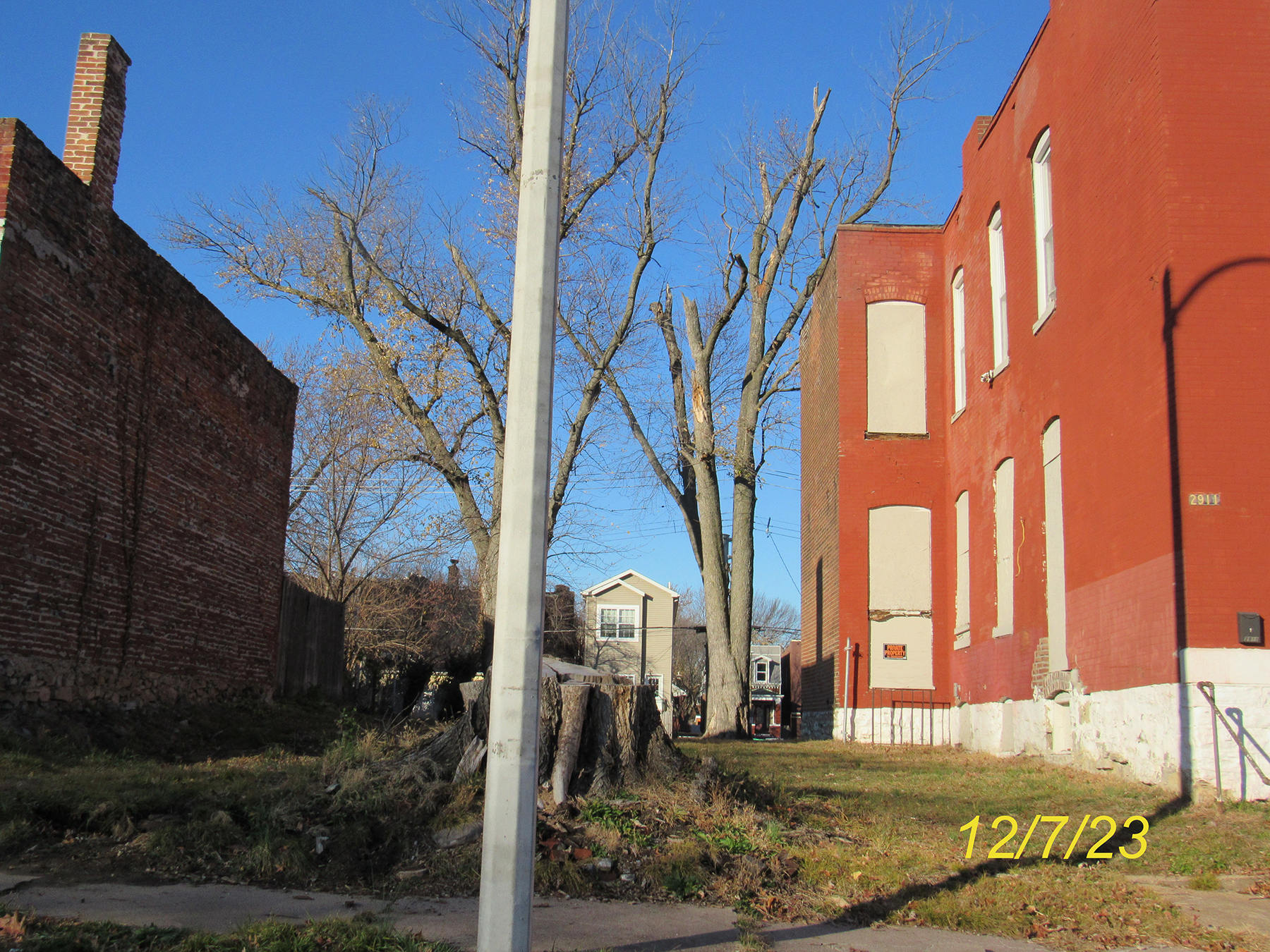
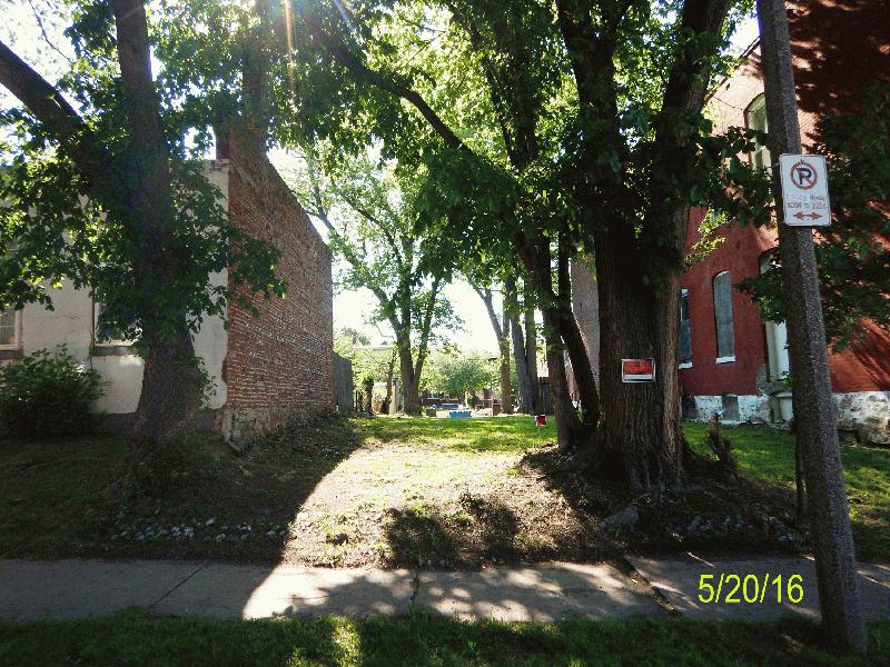
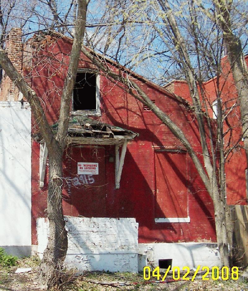
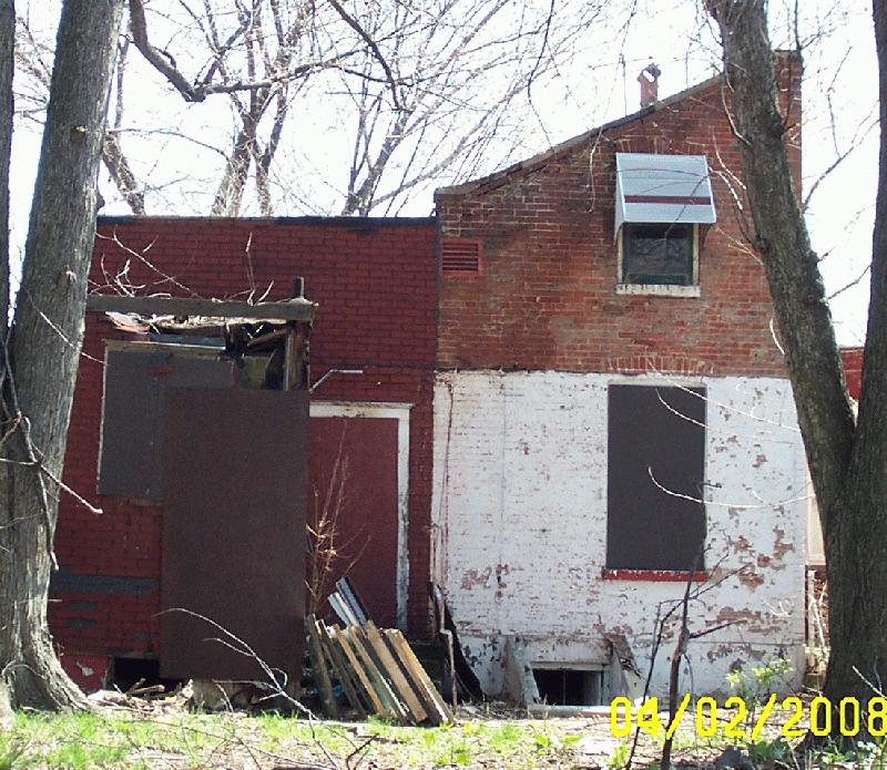
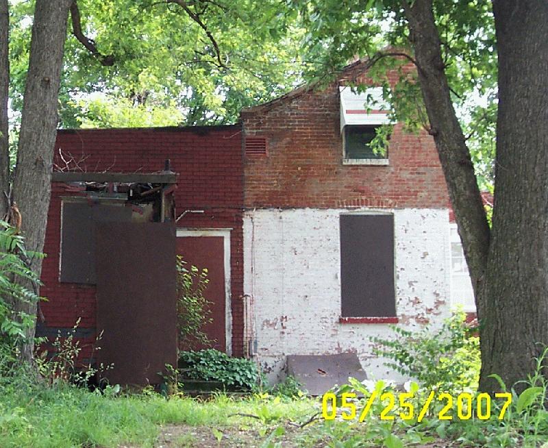
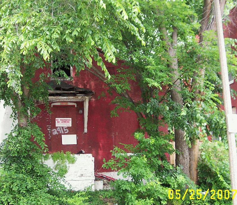
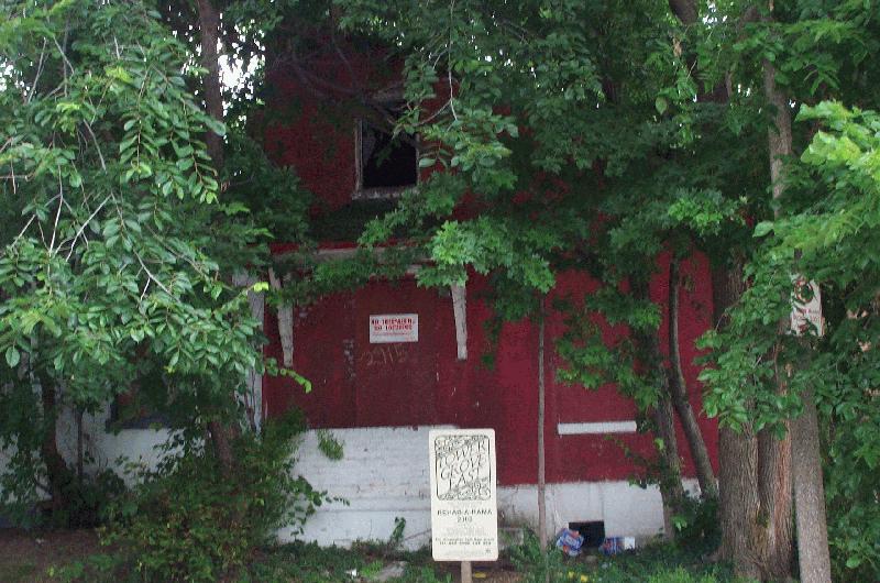
Images
Parcel Information
| Condominium | No |
|---|---|
| Number of units | n/a |
| Frontage | 25.00 feet |
| Land area | n/a |
| Property description
Not meant for use in recorded legal documents |
C. B. 1454 MINNESOTA AV, 25 FT X 125 FT, 3RD CITY ADDN, BLOCK 1, LOT 15 |
Land Use Information
| Property use | Vacant Residential Lot |
|---|---|
| Property class | EXEMPT |
| Zoning | B - Two Family Residential |
| Within 1/2 mile of planned Green Line stations | No |
| Redevelopment code | N/A |
| Vacant lot | No |
| Deed records: | Search Recorder of Deeds data |
Appraised Value
Please note that this parcel is tax abated under both Missouri Statue and City of St. Louis ordinance. Under the terms of the abatement, the assessment does NOT have a direct correlation to market value for the duration of the abatement. As an abated parcel, the Assessor does not determine an estimate of market value for biennial reassessment. The market value shown is merely the assessed value divided by the appropriate assessment ratio.
BackAssessment Information
The assessed value reflects the parcel/property as it existed on January 1 of the appropriate assessment year. Any changes made to the parcel/property after January 1st will be reflected after the next reassessment of the property.
Current 2025 Assessed Values
Prior 2024 Assessed Values
Sales History
| Sales date | Sales Price | Transaction Type |
|---|
No records found
Real Estate Tax Summary
Data provided by Collector of Revenue
Collector of Revenue Account Number: 1454-00-02600
This property is exempt and has no tax records for the last three years.
Building Permit Records
| Owner Name | Permit Type | Application Date | Completion Date | Issued Date | New Use | Estimated Costs | Description |
|---|---|---|---|---|---|---|---|
| L R A | Demolition | 08/21/2008 | 10/02/2008 | 08/27/2008 | $7,200.00 | HANDWRECK 1 STORY 1 FAMILY FRAME HOUSE | |
| Plumbing | 08/14/2008 | 08/14/2008 | 08/14/2008 | $250.00 | TAP DESTROY | ||
| Plumbing | 12/17/1993 | 12/17/1993 | $1,900.00 | CITY SEWER REPAIR SLP 94-455 | |||
| Demolition | 05/25/1993 | 09/15/1993 | 06/04/1993 | $300.00 | WRECK 1 CAR BRICK & WOOD GARAGE |
Data provided by Building Permits Section
Boundaries and Geography
Geographic Boundaries
| City block number | 1454.00 |
|---|---|
| Neighborhood | 25 - Tower Grove East |
| Ward/Precinct | Ward 07, Precinct 7 |
| Census tract | 1165.00 |
| Census block | 4020 |
| Assessment neighborhood | R244 |
| Housing conservation dist. |
Your Address is in Housing Conservation District Number 81. (What Are the Requirements for Housing Conservation Districts?) |
| Zoning | B - Two Family Residential |
Economic Development Areas
| TIF district number | No |
|---|---|
| Enterprise Zone | No |
| HUBZone | Yes (More Info) |
| HUD qualifying census tract (2022) | No (More Info) |
| Community needs grant | No (See Ordinance 71504) |
| Midtown redevelopment | No |
| Special business district | No |
Trash and Maintenance
Data provided by Streets Department
Refuse Schedule
Roll Out Carts
Showing regular schedules below. View Holiday Schedule.
Trash: Tuesday
Recycling: Friday
Yard waste: Wednesday
Yard Waste collection is discontinued in the middle of December and resumes in the middle of March.
Large bulk items: Week of the 2nd Monday of the month
Alley Dumpsters
August 15, 2025: The City has ended alley recycling due to ineffectiveness and high costs, and will instead grow its efforts toward the collection of trash. Constituents with alley recycling dumpsters should use our Drop-Off Recycling Locations. Roll cart recycling will continue.
Trash: At least once per week
Recycling: At least once per week
Yard waste: Friday
Yard Waste collection is discontinued in the middle of December and resumes in the middle of March.
Large bulk items: Week of the 2nd Monday of the month
Street Cleaning Schedule
Route: 7B
Days: Second Monday/Second Tuesday
Times: 12:00 PM - 3:30 PM
Notes: Utah St Second M/T PM; Wyoming St Second M/T PM
Seasonal Cleanup
Forestry Cutting Schedule
On the cutting schedule: Yes
Previous vacant lots cut: 08/13/2025
Next vacant lots cut: 09/19/2025
Operation Brightside
OB Region: Region 2 South
Snow Route
Help Us Improve This Page
Did you notice an error? Is there information that you expected to find on this page, but didn't? Let us know below, and we'll work on it.
Feedback is anonymous.
73 comments from people like you have helped us improve this page. Keep the feedback coming!