Ward 07 2021 Map
Ward 07 2021 Map
Publication Date: 03/02/2022
Document Type: Maps and GIS
Sponsor:
Planning & Urban Design Agency
Summary
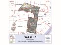
All of that portion of St. Louis City County bounded and described as follows:
Beginning at the point of intersection of S Vandeventer Ave and I- 44, and proceeding northerly along S Vandeventer Ave to Chouteau Ave, and proceeding easterly along Chouteau Ave to S Jefferson Ave, and proceeding southerly along S Jefferson Ave to Park Ave, and proceeding westerly along Park Ave to S Jefferson Ave, and proceeding southerly along S Jefferson Ave to Winnebago St, and proceeding westerly along Winnebago St to S Grand Blvd, and proceeding northerly along S Grand Blvd to Shenandoah Ave, and proceeding easterly along Shenandoah
Ave to Nebraska Ave, and proceeding northerly along Nebraska Ave to I- 44, and proceeding westerly along I- 44 to the point of beginning.
Population: 21,361
Download
-
 Ward 7 2021 11x17
(14.26 MB)
Ward 7 2021 11x17
(14.26 MB)
Need Help Viewing?
You need a program that can open Adobe PDF files. A free option:
- Adobe Reader (can read PDF files)