Ward 10 2021 Map
Ward 10 2021 Map
Publication Date: 03/02/2022
Document Type: Maps and GIS
Sponsor:
Planning & Urban Design Agency
Summary
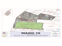
All of that portion of St. Louis City County bounded and described as follows:
Beginning at the point of intersection of the St. Louis City county line and Clayton Rd, and proceeding northerly along the St. Louis City county line to Page Blvd, and proceeding easterly along Page Blvd to Union Blvd, and proceeding northerly along Union Blvd to Dr Martin Luther King Dr, and
proceeding easterly along Dr Martin Luther King Dr to N Taylor Ave, and proceeding southerly along N Taylor Ave to Delmar Blvd, and proceeding westerly along Delmar Blvd to Union Blvd, and proceeding southerly along Union Blvd to Lindell Blvd, and proceeding easterly along Lindell Blvd to N Kingshighway Blvd, and proceeding southerly along N Kingshighway Blvd to S Kingshighway Blvd, and proceeding southerly along S Kingshighway Blvd to Oakland Ave, and proceeding westerly along Oakland Ave to Clayton Ave, and proceeding westerly along Clayton Ave to Clayton Rd, and proceeding westerly along Clayton Rd to the point of beginning.
Population: 20,922
Download
-
 Ward 10 2021 11x17
(14.60 MB)
Ward 10 2021 11x17
(14.60 MB)
Need Help Viewing?
You need a program that can open Adobe PDF files. A free option:
- Adobe Reader (can read PDF files)
Help Us Improve This Page
Did you notice an error? Is there information that you expected to find on this page, but didn't? Let us know below, and we'll work on it.
Feedback is anonymous.